Economic Geographies of the West Midlands - Current Features and Future Implications
By SQW (Stuart Wells), City-REDI and Automatic Knowledge, January 2025

In December 2024 the West Midlands Combined Authority (WMCA) published a study on Economic Geographies of the West Midlands co-authored by SQW, City-REDI and Automatic Knowledge. The purpose of the report was to expand and deepen understanding of the economic geographies of the West Midlands, with a particular focus on the interdependencies and connections between places within the region and how these might evolve in the future given key megatrends.
Analysis of flows
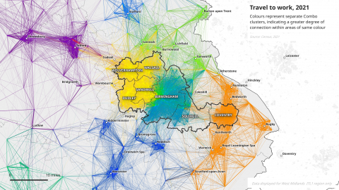
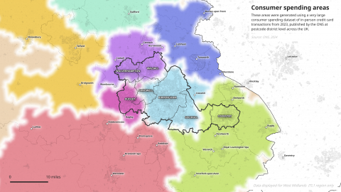
The study involved analysis of micro-area level data on commuting and migration from the 2011 and 2021 Census of Population, consumer spend data from the Office for National Statistics and mobile-phone generated origin-destination Mobile Network Data from the BT Group using COMBO: a network partitioning algorithm. The figures below are selected examples of the maps from the study, displaying travel-to-work data and consumer spending data, respectively.

Map credit: Alasdair Rae. Automatic Knowledge analysis of travel to work data, Census 2021.

Map credit: Alasdair Rae. Automatic Knowledge analysis of consumer card spend data, ONS 2024.
Across all the different indicators mapped there is some evidence for polycentricity – albeit the functional economic area with Birmingham at its core is bigger than the other areas. When different indicators are combined, three key geographies emerge within and across the WMCA area:
- Birmingham - with large parts of Solihull and parts of Sandwell
- The Black Country - which subdivides on certain indicators)
- Coventry - with a small part of Solihull and with Warwickshire
This signals that the West Midlands is different from monocentric city regions, such as London and Greater Manchester – albeit Birmingham is the major regional centre with considerable assets for agglomeration economies within the wider polycentric West Midlands structure.
The ‘boundaries’ of the different areas in the West Midlands are porous. On many of the indicators, functional economic relationships are evidently overlapping. This suggests that the situation on the ground is ‘messy’ and there are no ‘hard edges’. However, the picture also varies and in reality the different areas may well be ‘layered’ such that particular places are in multiple geographies.
It is clear also that there are some strong links with places outside of the WMCA area. This means that the WMCA area’s overall socio-economic character and performance has been shaped not only by its constituent authorities but also by Kidderminster, Bromsgrove, Redditch, Warwick/ Leamington Spa, Nuneaton, Tamworth, Lichfield and Cannock. This means that the WMCA needs a constructive and creative dialogue with its near neighbours – particularly in Warwickshire, northern Worcestershire and southern Staffordshire.
Looking ahead and implications
Megatrends such as technological change and digitisation, adaptation to climate change and the transition to net zero carbon, and geopolitical developments will shape economic geographies over the medium- and longer-term. For individuals, it is likely that functional economic geographies will be increasingly differentiated, varying by age, occupation and income/wealth. Relationships between home and work will be more complicated and less predictable. Insofar as future social and economic life does depend on in-person interactions, the transport infrastructure will continue to be crucially important.
Digitisation will lead to a range of effects, opening up greater possibilities for living in the West Midlands and working elsewhere or working in the West Midlands and living elsewhere – at least for some people, while for others life worlds will be extremely localised. The recent increase in remote/hybrid working may have implications for innovation and productivity. It also emphasises the importance of considering what makes places attractive - in terms of living, working and enjoying leisure for different segments of the population. The environmental dimensions of engaging with work, leisure and key services will have a bearing on functional economic space driven by changing values and a more widespread acceptance of the need to reduce individual carbon footprints.
Overall, megatrends combine in different ways to influence the nature and timing of work, patterns of leisure-related consumption and supply chain dynamics and so shift the underpinning functional economic geographies of the West Midlands. These geographies continue to be shaped by the transport infrastructure, settlement patterns, economic and social structures, demography, and income and wealth distribution. This means that effective functional geographies are changing and becoming more complex: some are shrinking, while others become larger. However, most will be capable of being influenced, directly or indirectly, by local, regional and/or national policies. In relation to transport, for example, ticketing policies, joined-up services, road pricing, active travel and sustainable transport measures have an influence on travel patterns. Policies linked to the allocation and delivery of both housing sites and employment land will have an impact over the medium- and long-term. Measures linked to employability and skills will influence how people can participate and benefit from opportunities, and here the digital infrastructure and digital skills will be critical.
The West Midlands has a rich and diverse geography. A key challenge for the WMCA and its partners is how it uses its powers and this geography going forward.
For further details read the full report.